
Learn More

Konveio 4.5 introduces powerful new engagement tools, expanded reporting capabilities, and major improvements to accessibility and project organization. This release continues our focus on making collaboration more interactive, measurable, and scalable across complex projects.
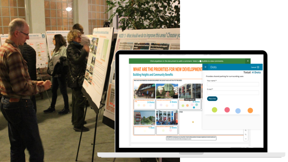
Enable stakeholders to quickly prioritize feedback by adding dots directly on documents - just like you do at your in-person events. Dot voting makes it easier to surface consensus and identify key issues at a glance. Admins have flexible configuration options, including controlling where users can add dots—making it adaptable for both formal decision-making and lightweight feedback exercises.
User tracking for demographic information or content gating is now more powerful and flexible:
This gives teams deeper insight into participation, engagement, and decision-making.
We’ve introduced a new map input field for Forms, extending our Esri integrations directly into webforms. This allows you to display interactive ArcGIS maps where users can drop pins or select features while submitting feedback. Attribute data from connected maps can automatically populate form fields, enabling richer, location-based input without additional setup.
Paired with new JSON and GeoJSON sync options, teams can easily push webform results back into ArcGIS or other GIS and data platforms, creating a seamless loop between public engagement and spatial analysis workflows.
Managing large projects is easier with:
We’ve also made a series of improvements to polish the experience and add new capabilities:
This release also includes a broad set of bug fixes and refinements focused on improving platform stability, performance, and usability. Enhancements include better mobile responsiveness, improved document handling, more reliable notifications and integrations, and continued progress on accessibility and compliance standards.
At Konveio, we’re always working to make community engagement smoother, more accessible, and more impactful. Our 4.4 release introduces a set of new features and enhancements that give facilitators, project teams, and participants more flexibility and insight than ever before.

Bring your projects to life with our ArcGIS 3D Scene integration. Participants can now explore planning in three dimensions, making spatial context easier to understand while adding elevation to the feedback you collect. Participants can more easily grasp proposed changes in 3D, helping them understand scale, relationships, and impacts more clearly while making feedback more educated.
Building inclusive engagement means understanding who is participating — without creating unnecessary hurdles. Konveio now allows you to use forms as splash pages to gather important participant information, such as demographics, before commenting. This approach removes the need for registration, making it easier for more people to share their voices while still giving you the insights you need.
By automatically merging this demographic and participation data into exports for Discussions and Documents, you gain a clearer picture of who you’re reaching, and who might still be missing from the conversation. The result: richer data, more equitable outreach, and smoother onboarding experiences that welcome diverse audiences into the process.
The Plan Library now comes with a new display mode: the Explorer always visible on top, with tabs for List and Map views below. Users can quickly switch between different ways of exploring your plans & policies, enhancing usability and accessibility.
We’ve given our Page builder (formerly Overviews) a facelift. Now with better sorting for sections and more flexible tiles and embed options for Activities like documents, discussions, and forms. Project teams can present content in clearer, more engaging layouts, making it easier for participants to navigate and interact.
Introducing the Themes by Project feature: a powerful way to summarize comments across multiple documents and discussions. See the big picture at a glance. This makes it easier for facilitators and stakeholders to identify emerging themes, trends, and areas of consensus across an entire project.
We’ve also made a series of improvements to polish the experience and add new capabilities:
Alongside these big updates, we’ve fixed a wide range of issues — from export nesting bugs and spell-check quirks to mobile navigation improvements and discussion AI summary styles. These fixes ensure Konveio runs more smoothly and reliably across devices and use cases.
This release is about giving you more power, clarity, and flexibility in how you engage communities. Whether you’re leveraging 3D maps for immersive discussions, tracking participants with multiple webforms, or summarizing themes across an entire project, Konveio continues to evolve with your needs.
Our 4.3.1 release builds on Konveio’s mission to make digital engagement more accessible, intuitive, and effective. This update introduces new tools for mapping, improvements for surveys and exports, and thoughtful refinements that help you capture richer input while keeping discussions safe and inclusive.
We’ve added swipe maps to Discussions, allowing participants to compare different ArcGIS map layers interactively and leave comments. Feature Attributes and IDs can now be saved alongside map comments, which enables managers to easily use Konveio's AI analysis to generate themes by attribute, e.g. summarize "themes by residential neighborhood". Helps participants explore different data perspectives side by side, leading to more informed and contextual feedback.
We’ve introduced a category field for map comments, with marker colors to help organize and visualize feedback at a glance. On top of that, UI improvements — including zoom controls, location search, and form overlays — make map-based commenting smoother and more intuitive. The simplified navigation and clearer visual distinctions make it simple for participants to engage meaningfully with map-based projects.
We’ve rolled out a new set of features tailored to Reg19 processes in the UK, ensuring compliance and smoother workflows for planning consultations. Local authorities and project teams working under Reg19 can streamline participation, feedback collection, and reporting in a way that aligns with legal and procedural requirements.
This release also resolves several quirks, including issues with comment imports (status handling and empty lines), making your workflow more reliable and frustration-free.
The 4.3.1 release strengthens Konveio’s mapping and survey capabilities while introducing critical safeguards and compliance features. Whether you’re facilitating discussions with swipe maps, exporting comments for stakeholders, or running statutory processes like Reg19, these updates are designed to make participation easier, clearer, and more inclusive.


