

.png)

Features
Beyond Just Basemaps: How Konveio’s ArcGIS Form Field Goes Further Than Survey123
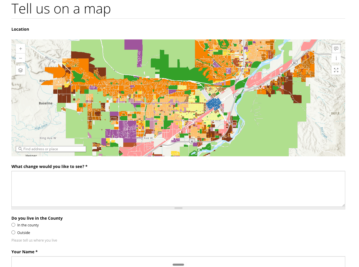
Esri’s Survey123 is often the default choice when teams need to collect location-based input. It’s reliable, familiar, and well integrated into the ArcGIS ecosystem. But as public engagement evolves beyond basic data collection, many planning teams are running into the same limitation: Survey123 treats maps as generic backdrops, not as meaningful project context.
Konveio’s new ArcGIS map field inside the form builder was designed to solve exactly that problem.
The Basemap Problem with Traditional Survey Tools
Out of the box, Survey123’s web form builder limits users to a predefined set of basemaps. While there are workarounds, adding custom ArcGIS Online maps—with your zoning layers, opportunity sites, policy overlays, or symbology—is surprisingly difficult.
For planning projects, that’s a big issue. Public feedback is only as good as the context people are responding to. Asking residents to drop a pin on a plain basemap strips away the very information they need to give informed, location-specific input.
Konveio Uses Your ArcGIS Maps — As-Is
Konveio’s form builder allows you to embed existing ArcGIS Online maps or scenes directly into a form field, exactly as they were designed.
That means:
- All project-specific layers are visible
- Pop-ups work as expected
- Symbology and labeling are preserved
- Participants see the same map planners and consultants use internally
Whether it’s a land use map, zoning layer, opportunity areas, or a 3D scene showing building heights, feedback happens in full context—not abstraction.

Capturing More Than Just a Point
Survey123 excels at capturing geometry (latitude and longitude), but analysis often stops there unless additional manual joins are performed later.
Konveio goes further by allowing responses to inherit attributes from the GIS features participants interact with. When someone drops a pin or clicks a parcel, Konveio can store:
- Parcel IDs
- Land use or zoning classifications
- Opportunity area identifiers
- Any relevant attribute table values
This information is saved alongside the participant’s response automatically.
The result? Cleaner analysis with far less manual GIS work. Instead of spatially joining survey points after the fact, planners can immediately filter and analyze feedback by district, land use type, or study area.
Designed for Planning Analysis, Not Just Data Collection
Survey123 is excellent for inspections, inventories, and structured internal workflows. Konveio’s ArcGIS form field is designed for something different: planning conversations that still produce structured, analyzable data.
Responses can be:
- Exported for GIS analysis
- Synced back to shapefiles if desired
- Filtered by spatial attributes without post-processing
It’s a small difference technically—but a big one operationally.
The Bottom Line
If your project only needs a pin on a basemap, Survey123 may be enough. But if you want people to respond to real planning maps, and if you want feedback that’s already enriched with GIS context, Konveio’s form builder with its new ArcGIS field offers a more planner-centric approach.
It doesn’t replace ArcGIS—it finally lets public input work the way ArcGIS users expect it to.


Similar posts


Explore a live example


